
Share

Copied
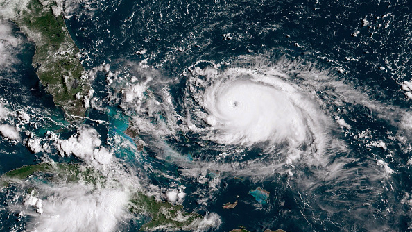
In this NOAA GOES-East satellite handout image, Hurricane Dorian, now a Cat. 5 storm, tracks towards the Florida coast taken at 13:20Z September 1, 2019 in the Atlantic Ocean. A hurricane warning is in effect for much of the northwestern Bahamas as it gets hit with 175 mph winds. According to the National Hurricane Center Dorian is predicted to hit the U.S. as a Category 4 storm. /Getty Images Photo
Hurricane Dorian beat a steady path north on Wednesday, as residents of coastal South Carolina braced for the region's worst flooding in 30 years, authorities and forecasters said.
Dorian was on the move along the U.S. coastline early, lashing the east coast of central Florida and eyeing the Carolinas, where mass evacuations have already been ordered.
South Carolina appeared to be in line for some of Dorian's worst.
If Thursday's water levels come in at 10 1/2 feet, that would be the second highest in Charleston County history, topped only by the 12.52-foot tide that struck Sullivan Island in the midst of Hurricane Hugo on Sept. 22, 1989.
Since Monday afternoon, a 100-mile stretch of Interstate 26, from coastal Charleston to inland Columbia, has been running one way, west. That lane reversal will end at noon on Wednesday.
"Now is the time to leave." according to a statement Wednesday morning by the South Carolina Emergency Management Division.
Slow-moving Dorian has already devastated parts of the Bahamas where it killed at least seven people when it virtually stalled out over the northwestern islands.
Rain bands from the storm were drenching the northeastern coast of Florida at 5 a.m. Wednesday, the national hurricane center said. The storm is expected to come "dangerously close" to Florida's east coast and the Georgia coast through Wednesday night, and forecasters with the National Hurricane Center say it will move near or over the South and North Carolina coasts Thursday through Friday morning.
Though the storm is now a Category 2 with maximum sustained winds of 105 mph — it was a Category 5 when it made landfall in the Bahamas on Sunday — officials have warned residents to take precautions and to heed evacuation orders as it has the potential to produce storm surges of several feet.
Federal emergency declarations have been approved for four states — Florida, Georgia, South Carolina and North Carolina — and the governor of Virginia had also declared a state of emergency.
The hurricane is expected to remain at about the same intensity for the next couple of days, and even if it does not make landfall, hurricane-force winds are expected to reach parts of the coast from central Florida to North Carolina, the hurricane center said.
Source:CNN